Trip Itinerary
Day 01: Arrival in Kathmandu and trip preparation (1,300m/4,264 ft)
Day 02: Fly to Lukla, trek to Phakding (2,651m/8,700ft): 8km, 3 - 4 hours trek
Day 03: Phakding to Namche Bazaar (3,438m/11,280 ft): 11km, 5 - 6 hours
Day 04: Acclimatization Day - Namche Bazaar: (3,440m/11,284ft)
Day 05: Namche Bazaar to Tengboche (3,870m/12,694ft): 10km, 5 - 6 hours
Day 06: Tengboche to Dingboche (4,360 m/14,300 ft): 9km, 5 - 6 hours
Day 07: Dingboche: Acclimatization
Day 08: Dingboche to Lobuche (4940 m/16,207 ft): 7km, 5-6 hours
Day 09: Lobuche to Gorak Shep (5,170 m/16,961ft), visit Everest Base Camp (5,364 m/17,594 ft
Day 10: Gorak Shep to Kala-Pathar (5,545m/18,192ft) to Pheriche (4,288m/14,070ft):
Day 11: Pheriche to Namche Bazaar (3,440m/11,280 ft): 20km, 6 - 7 hours
Day 12: Namche Bazaar to Lukla (2,860m/9,186ft): 19km, 6 - 7 hours
Day 13: Fly to Kathmandu
Day 14: Final departure
Everest Base Camp Nepal
The Everest Base Camp trek on the south side is one of the most popular trekking routes in the Himalayas and about 40,000 people per year make the trek there from Lukla airport. Trekkers usually fly from Kathmandu to Lukla to save time and energy before beginning the trek to this base camp. However, trekking to Lukla is possible. There are no roads from Kathmandu to Lukla, but its possible to to travel half way by bus or jeep and start trek from salleri or phaplu and as a result, these both are ways of transporting large and heavy goods.
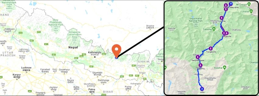
Everest Base Trek Route Map from Nepal side
From Lukla, climbers trek upward to the Sherpa town of Namche Bazaar, 3,440 metres (11,290 ft), following the valley of the Dudh Kosi river. It takes about less then two days to reach the village, which is a central hub of the area. Typically at this point, climbers allow a day of rest for acclimatization. They then trek another two days to Dingboche, 4,260 metres (13,980 ft) before resting for another day for further acclimatization. Another two days takes them to Everest Base Camp via Gorakshep, the flat field below Kala Patthar, 5,545 metres (18,192 ft) and Mt. Pumori.


.jpg)


(3).jpg)
